
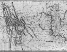
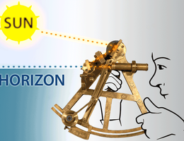
For Lewis and Clark, as well as the explorers who followed them, one of their main tasks was to map an unknown territory. Maps would allow trappers, immigrants and settlers to find their way west. To draw the maps, Lewis and Clark had to figure out the longitude and latitude at each point, and they relied on the best technology available at the time:
• a sextant, which cost $77
• an octant
• an artificial horizon
• a surveying compass
• and a scientific pocket watch called a "Gold Chronometer." The watch itself cost $250, a large sum at the time.
All of these instruments allowed Lewis and Clark to figure out the course of the Missouri River and their route to the Pacific.
So how do you find the latitude of a given point on the earth’s surface? Lines of latitude are imaginary circles that start at the equator which is known as 0 degrees of latitude. Imagine that there’s a line from the equator at the surface to the center of the Earth. Then imagine a line from the center of the Earth to the point on the surface where you are standing, say in present-day Nebraska. The angle from 0-degrees to your position is the latitude.
Finding the longitude of a given point was a little more difficult. Imagine that there is a plane that is inserted into the Earth that runs from the North Pole to the South Pole. Navigators had to randomly choose a starting point for their measurements and they chose a line going through Greenwich, England. As you move west, lines of longitude are measured in degrees off of the Prime Meridian. The 100-degree meridian is located near present-day Cozad.
When Lewis and Clark set off, none of the map coordinates in the Louisiana Purchase had been charted. They used their tools and techniques to determine them.
Meriwether Lewis, William Clark and around 48 other members of the expedition left St. Louis on May 14, 1804. They traveled in a big keelboat that was 55 feet long, 8 feet wide and capable of carrying 10 tons of supplies. They also have two smaller boats called pirogues. They sailed by rowing, setting poles and sometimes by wading ashore and pulling the boat with ropes. They make 14 miles up river on a good day and passed a few trappers coming down to sell their pelts in St. Louis. By May 25th they passed the settlement of La Charette, a cluster of seven dwellings less than 60 miles west of St. Louis. Charles Floyd notes in his journal, this is "the last settlement of whites on this river."
They made it to present-day Nebraska on July 15th, making camp near the Little Nemaha River. Clark reported that, "I saw Great quantities of Grapes, Plums, of 2 Kinds, wild Cherries of 2 Kinds, Hazelnuts, and Gooseberries."
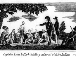
On July 21, they reached the mouth of the Platte where it enters the Missouri. The next day, they went 10 more miles up river and decided to stop and make contact with the local Indians. It was here that they held their first "Council" or discussion with local tribes. The Americans offered gifts of roast meat, flour, and corn meal, and the Indians responded with a gift of watermelons. Although the search for a Northwest Passage was their primary goal, Lewis and Clark had been commanded by Jefferson to complete anthropological, diplomatic and commercial missions to the Missouri River Indian tribes. Lewis had worked out a standard speech that promised military protection and trade advantages in return for peace with the tribes. The first nations to hear this pitch were the Otos and the Missourias, at a council held on August 3, north of present-day Omaha. The Indians responded favorably because they needed both the trade goods offered and protection from their northern neighbors, the Teton Sioux. The site became known as "Council Bluff".
Although there was only one fatality on the expedition, the explorers suffered from a variety of illnesses and accidents. On August 22, Captain Lewis became ill. Although the cause is unknown, Captain Clark mistakenly believed it was caused by arsenic in rocks Lewis had examined. On the return journey in 1806, Lewis was injured in a hunting accident.
One of the reasons they were able to survive is that they made friends and were taken in by the Mandan and Hidatsas. On October 24, 1804, the Corps reached the Mandan Villages north of what is now Bismarck, North Dakota. There they found earth lodges housing 4,500 people — a larger city than St. Louis or even Washington D.C. at the time! The Captains decide to build their own dwellings across the river from the main village and call it Fort Mandan. But they developed close ties with the tribe and with some of the fur traders living with them. It was here that they meet and hire Toussaint Charbonneau, a French Canadian fur trader, and his young Shoshone wife Sacagawea.
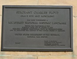
Considering the hazards of a two-year trip across uncharted territory, the fact that Floyd was the only fatality is remarkable. A monument in his memory was erected near Sioux City, Iowa in 1901.